Mount Augustus or Burringurrah is one of the most spectacular solitary peaks of the world's largest monoclines, it rises above a stoney, red sandplain of arid scrubland and is visible from the air for more than 160 kms. The granite formation is about 8 kms long, covers an area of 4,795 hectares and is estimated to be 1,750 million years old.
The area around Mount Augustus is the traditional lands of the Wajarri tribe. Burringurrah is the Wajarri name for Mount Augustus. Aboriginal occupation is evident by the engravings on rock walls at Mundee, Ooramboo and Beedoboondu visitor sites.
Francis Thomas Gregory was the first non-indigenous person to climb to the summit on 3rd June 1858 during his epic 107 day journey through the Gascoyne region. Some weeks later he named the peak after his brother, Augustus Charles Gregory, later Sir Augustus (1819 - 1905)
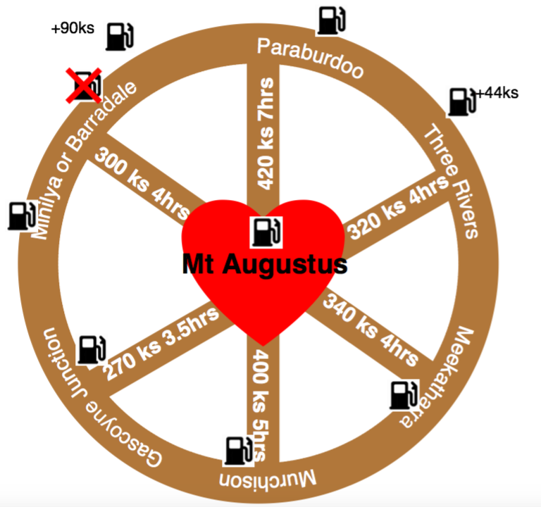
AccessMount Augustus Tourist Park is 430 km from Carnarvon via Gascoyne Junction and 360 km from Meekatharra. Roads are gravel but suitable for two wheel drive vehicles.
Roads may be closed or substantially damaged after heavy rain. Before travelling, seek advice from the local shires. Carry ample fuel, water and supplies to cope with all possible occurrence's. Gascoyne Shire 08 99430988 www.uppergascyone.wa.gov.au Meekatharra Shire 08 99800600 www.meekashire.wa.gov.au Murchison Shire 08 99637999 www.murchison.wa.gov.au Ashburton Shire O891884444 www.ashburton.wa.gov.au Driving times and distances to Mt Augustus Tourist Park information provided on other web sites regarding travel times are hugely inaccurate. The mud map to the left provides more accurate information on travel times and distances. |
Flights to Mt Augustus Tourist Park
Shine Avation Geraldton WA 08 99233600
Sharkbay Air Charter WA 08 99481773 www.sharkbayair.com.au
Norwest Air WA 08 99492888 www.norwestairwork.com.au
Geraldton Air Charter 08 99233434 www.geraldtonaircharter.com
Coach Companies to Mt Augustus Tourist Park
Casey Tours 1800 999 677 www.caseytours.com.au
Naturetime Outback and Photography Tours www.naturetimetours
Accommodation & Camping
No camping or open fires are permitted within the National Park or on Mount Augustus Station pastoral lease.
Accommodation, powered caravan sites, camping facilities, fuel and water are available at Mount Augustus Tourist Park, phone (08) 99430527
Accommodation, powered caravan sites, camping facilities, fuel and water are available at Mount Augustus Tourist Park, phone (08) 99430527
Climate Information
The temperature ranges from mid 20° celcius during the winter up to the mid 40° celcius in the summer. The nights can get quite cool during the winter although they are warm during summer. Rain season is heaviest during December to April as this is cyclone season in Western Australia.
To check for current weather you can go to www.accuweather.com and click on the Mt Augustus link.
To check for current weather you can go to www.accuweather.com and click on the Mt Augustus link.

